Geolocate

Sperone topographic map

Click on the map to display elevation.

About this map

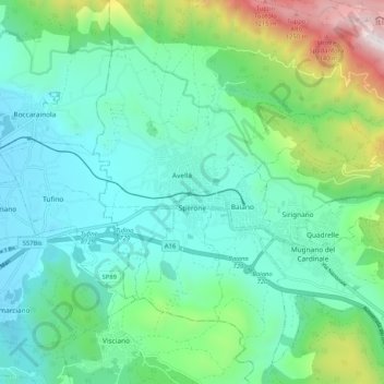
Name: Sperone topographic map, elevation, terrain.

Location: Sperone, Avellino, Campania, Italy (40.92941 14.58788 40.98167 14.69080)

Average elevation: 373 m

Minimum elevation: 66 m

Maximum elevation: 1,395 m

Other topographic maps

Click on a map to view its topography, its elevation and its terrain.

Santa Barbara

Italy > Campania > Avellino > Ariano Irpino

Average elevation: 461 m

Ariano Scalo

Italy > Campania > Avellino > Ariano Irpino

Average elevation: 576 m

Quaglietta

Italy > Campania > Avellino > Calabritto

Average elevation: 320 m

Gear up for your next adventure:

🔦LED Flashlight - Powerful and long-lasting flashlight for camping and emergencies
🥾Hiking Shoes - Durable and comfortable shoes for trail hiking
👟Sport Hiking Sandals - Breathable footwear for water crossings and camp rest
💧Reusable Water Bottle - Durable water bottles for hydration on trails
🥾Trekking Poles - Adjustable trekking poles to reduce knee stress and improve stability

As an Amazon Associate, this site earns from qualifying purchases at no extra cost to you.