Geolocate

Guinea topographic map

Click on the map to display elevation.

About this map

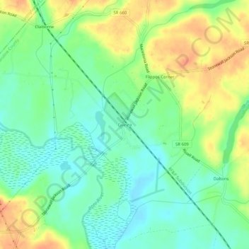
Name: Guinea topographic map, elevation, terrain.

Location: Guinea, Caroline County, Virginia, 22580, United States (38.12409 -77.45911 38.16409 -77.41911)

Average elevation: 48 m

Minimum elevation: 28 m

Maximum elevation: 76 m

Other topographic maps

Click on a map to view its topography, its elevation and its terrain.

Lake Land'Or

United States > Virginia > Caroline County

Average elevation: 79 m

Pettigrew

United States > Virginia > Caroline County > Haymount

Average elevation: 39 m

Gear up for your next adventure:

🥘Camping Cookware Set - Compact nesting pots and pans for trail cooking
🔦LED Headtorch - Bright and durable light for night activities
🥾Trail Hiking Shoes - Durable shoes designed for rugged trails
🛌Down Sleeping Bag - Superior warmth-to-weight ratio for cold nights
🥾Trail Hiking Boots - Supportive boots for rough trails

As an Amazon Associate, this site earns from qualifying purchases at no extra cost to you.