
Make a donation
Gear up for your next adventure:
As an Amazon Associate, this site earns from qualifying purchases at no extra cost to you.
Elkins topographic map
Click on the map to display elevation.
Make a donation
Gear up for your next adventure:
As an Amazon Associate, this site earns from qualifying purchases at no extra cost to you.
Elkins
Elkins is located at the confluence of the Tygart Valley River and Leading Creek. The average elevation is 2,000 feet (610 m) above sea level. According to the United States Census Bureau, the city has a total area of 3.43 square miles (8.88 km2), all land. Elkins is headquarters for the Monongahela National Forest, a 910,155-acre (368,327 ha) federal reserve encompassing the "High Alleghenies" area to the east of the city.
Make a donation
Gear up for your next adventure:
As an Amazon Associate, this site earns from qualifying purchases at no extra cost to you.
About this map
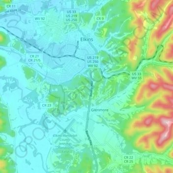
Name: Elkins topographic map, elevation, terrain.
Location: Elkins, Randolph County, West Virginia, 26241, United States (38.87325 -79.87408 38.94134 -79.83184)
Average elevation: 637 m
Minimum elevation: 576 m
Maximum elevation: 861 m
Make a donation
Gear up for your next adventure:
As an Amazon Associate, this site earns from qualifying purchases at no extra cost to you.