Geolocate

Kahului topographic map

Click on the map to display elevation.

About this map

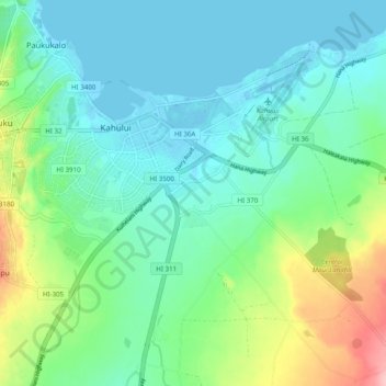
Name: Kahului topographic map, elevation, terrain.

Location: Kahului, Maui County, Hawaii, 96784, United States (20.84547 -156.50042 20.90215 -156.40225)

Average elevation: 37 m

Minimum elevation: -3 m

Maximum elevation: 152 m

Other topographic maps

Click on a map to view its topography, its elevation and its terrain.

Puʻunene

United States > Hawaii > Maui County > Kahului

Average elevation: 25 m

Gear up for your next adventure:

🪑Ultralight Camping Stool - Compact seating for rest stops during long hikes
🧢Hiking Sun Hat - Wide-brimmed protection for exposed mountain ridges
🔭Compact Monocular - One-handed bird watching and trail spotting
🥾Hiking Leggings - Comfortable leggings for outdoor activities
🛌Insulated Sleeping Pad - Critical thermal barrier between you and the cold ground

As an Amazon Associate, this site earns from qualifying purchases at no extra cost to you.