
Make a donation
Gear up for your next adventure:
As an Amazon Associate, this site earns from qualifying purchases at no extra cost to you.
Lerné topographic map
Click on the map to display elevation.
Make a donation
Gear up for your next adventure:
As an Amazon Associate, this site earns from qualifying purchases at no extra cost to you.
About this map
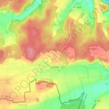
Name: Lerné topographic map, elevation, terrain.
Average elevation: 83 m
Minimum elevation: 32 m
Maximum elevation: 123 m
Make a donation
Gear up for your next adventure:
As an Amazon Associate, this site earns from qualifying purchases at no extra cost to you.
Other topographic maps
Click on a map to view its topography, its elevation and its terrain.
Château de Cinq-Mars-la-Pile
France > Centre-Val de Loire > Indre-et-Loire > Cinq-Mars-la-Pile > Le Bourg
Average elevation: 61 m
Make a donation
Gear up for your next adventure:
As an Amazon Associate, this site earns from qualifying purchases at no extra cost to you.
La Proutière
France > Centre-Val de Loire > Indre-et-Loire > Épeigné-sur-Dême
Average elevation: 106 m
Make a donation
Gear up for your next adventure:
As an Amazon Associate, this site earns from qualifying purchases at no extra cost to you.
Chausseloup
France > Centre-Val de Loire > Indre-et-Loire > Chanceaux-sur-Choisille
Average elevation: 96 m
Make a donation
Gear up for your next adventure:
As an Amazon Associate, this site earns from qualifying purchases at no extra cost to you.
La Terre de la Ceuille Roulée
France > Centre-Val de Loire > Indre-et-Loire > Langeais
Average elevation: 89 m
Les Coutures
France > Centre-Val de Loire > Indre-et-Loire > La Ville-aux-Dames
Average elevation: 57 m
Make a donation
Gear up for your next adventure:
As an Amazon Associate, this site earns from qualifying purchases at no extra cost to you.
La Foire de Saint-Roch
France > Centre-Val de Loire > Indre-et-Loire > Saint-Roch
Average elevation: 96 m
Saint-Sulpice
France > Centre-Val de Loire > Indre-et-Loire > Chambourg-sur-Indre
Average elevation: 90 m
Make a donation
Gear up for your next adventure:
As an Amazon Associate, this site earns from qualifying purchases at no extra cost to you.
Make a donation
Gear up for your next adventure:
As an Amazon Associate, this site earns from qualifying purchases at no extra cost to you.
Le Buisson
France > Centre-Val de Loire > Indre-et-Loire > Tauxigny-Saint-Bauld
Average elevation: 97 m
Make a donation
Gear up for your next adventure:
As an Amazon Associate, this site earns from qualifying purchases at no extra cost to you.
La Grangette
France > Centre-Val de Loire > Indre-et-Loire > Montlouis-sur-Loire
Average elevation: 59 m
Île de Porteau
France > Centre-Val de Loire > Indre-et-Loire > La Chapelle-sur-Loire
Average elevation: 34 m
Make a donation
Gear up for your next adventure:
As an Amazon Associate, this site earns from qualifying purchases at no extra cost to you.
Les Chauvelles
France > Centre-Val de Loire > Indre-et-Loire > Azay-le-Rideau > Lionnière
Average elevation: 81 m
Parc du Lac des Bretonnières
France > Centre-Val de Loire > Indre-et-Loire > Joué-lès-Tours > La Petite Carte
Average elevation: 85 m
Make a donation
Gear up for your next adventure:
As an Amazon Associate, this site earns from qualifying purchases at no extra cost to you.
Make a donation
Gear up for your next adventure:
As an Amazon Associate, this site earns from qualifying purchases at no extra cost to you.
La Grange du Bois
France > Centre-Val de Loire > Indre-et-Loire > Épeigné-les-Bois
Average elevation: 105 m
La Tuilerie
France > Centre-Val de Loire > Indre-et-Loire > La Croix-en-Touraine
Average elevation: 74 m
Château de Villandry
France > Centre-Val de Loire > Indre-et-Loire > Villandry > Le Château
Average elevation: 64 m
Make a donation
Gear up for your next adventure:
As an Amazon Associate, this site earns from qualifying purchases at no extra cost to you.
Le Puy Mary
France > Centre-Val de Loire > Indre-et-Loire > Le Petit-Pressigny
Average elevation: 123 m
Make a donation
Gear up for your next adventure:
As an Amazon Associate, this site earns from qualifying purchases at no extra cost to you.
La Vallée des Caves
France > Centre-Val de Loire > Indre-et-Loire > Rochecorbon
Average elevation: 110 m
Le Carroi
France > Centre-Val de Loire > Indre-et-Loire > Mazières-de-Touraine
Average elevation: 91 m
Make a donation
Gear up for your next adventure:
As an Amazon Associate, this site earns from qualifying purchases at no extra cost to you.
Make a donation
Gear up for your next adventure:
As an Amazon Associate, this site earns from qualifying purchases at no extra cost to you.
Parc du Val de Loire
France > Centre-Val de Loire > Indre-et-Loire > Montlouis-sur-Loire > Le Bourg
Average elevation: 63 m
Les Ansaults
France > Centre-Val de Loire > Indre-et-Loire > Artannes-sur-Indre
Average elevation: 73 m
Le Sabot Rouge
France > Centre-Val de Loire > Indre-et-Loire > Sainte-Maure-de-Touraine
Average elevation: 98 m
Make a donation
Gear up for your next adventure:
As an Amazon Associate, this site earns from qualifying purchases at no extra cost to you.
La Blottière
France > Centre-Val de Loire > Indre-et-Loire > Beaumont-Louestault
Average elevation: 121 m
Les Availlons
France > Centre-Val de Loire > Indre-et-Loire > Yzeures-sur-Creuse
Average elevation: 93 m
Le Bois de la Grille
France > Centre-Val de Loire > Indre-et-Loire > Chinon > Le Villier
Average elevation: 75 m
Make a donation
Gear up for your next adventure:
As an Amazon Associate, this site earns from qualifying purchases at no extra cost to you.
Les Hucherolles
France > Centre-Val de Loire > Indre-et-Loire > Chinon > Les Hucherolles
Average elevation: 57 m
Le Boulay
France > Centre-Val de Loire > Indre-et-Loire > Villedômer > Le Boulay
Average elevation: 118 m
Les Poulardières
France > Centre-Val de Loire > Indre-et-Loire > Saint-Cyr-sur-Loire
Average elevation: 70 m
Make a donation
Gear up for your next adventure:
As an Amazon Associate, this site earns from qualifying purchases at no extra cost to you.
Le Télégraphe
France > Centre-Val de Loire > Indre-et-Loire > Chambray-lès-Tours
Average elevation: 86 m
Le Grand Village
France > Centre-Val de Loire > Indre-et-Loire > La Ville-aux-Dames
Average elevation: 51 m
Make a donation
Gear up for your next adventure:
As an Amazon Associate, this site earns from qualifying purchases at no extra cost to you.
Les Muriers
France > Centre-Val de Loire > Indre-et-Loire > Saint-Pierre-des-Corps
Average elevation: 58 m
Make a donation
Gear up for your next adventure:
As an Amazon Associate, this site earns from qualifying purchases at no extra cost to you.
La Grosse Chaintre
France > Centre-Val de Loire > Indre-et-Loire > La Ville-aux-Dames
Average elevation: 61 m
Make a donation
Gear up for your next adventure:
As an Amazon Associate, this site earns from qualifying purchases at no extra cost to you.
La Derouette
France > Centre-Val de Loire > Indre-et-Loire > Coteaux-sur-Loire
Average elevation: 47 m
La Blonderie
France > Centre-Val de Loire > Indre-et-Loire > Beaumont-Louestault
Average elevation: 131 m
Make a donation
Gear up for your next adventure:
As an Amazon Associate, this site earns from qualifying purchases at no extra cost to you.
Make a donation
Gear up for your next adventure:
As an Amazon Associate, this site earns from qualifying purchases at no extra cost to you.
Pièce de Ferrière
France > Centre-Val de Loire > Indre-et-Loire > Athée-sur-Cher
Average elevation: 79 m
Make a donation
Gear up for your next adventure:
As an Amazon Associate, this site earns from qualifying purchases at no extra cost to you.
Le Mee
France > Centre-Val de Loire > Indre-et-Loire > Neuillé-le-Lierre > Le Feuillet
Average elevation: 103 m
Make a donation
Gear up for your next adventure:
As an Amazon Associate, this site earns from qualifying purchases at no extra cost to you.
Make a donation
Gear up for your next adventure:
As an Amazon Associate, this site earns from qualifying purchases at no extra cost to you.