
Make a donation
Gear up for your next adventure:
As an Amazon Associate, this site earns from qualifying purchases at no extra cost to you.
Cariño topographic map
Click on the map to display elevation.
Make a donation
Gear up for your next adventure:
As an Amazon Associate, this site earns from qualifying purchases at no extra cost to you.
Cariño
Die jährlichen Niederschläge im Gemeindegebiet schwanken zwischen rund 2.000 mm auf den Höhen der Serra da Capelada und rund 1.000 mm unten in der geschützten Bucht. Die mittlere Jahrestemperatur liegt bei 13–14 °C.
Make a donation
Gear up for your next adventure:
As an Amazon Associate, this site earns from qualifying purchases at no extra cost to you.
About this map
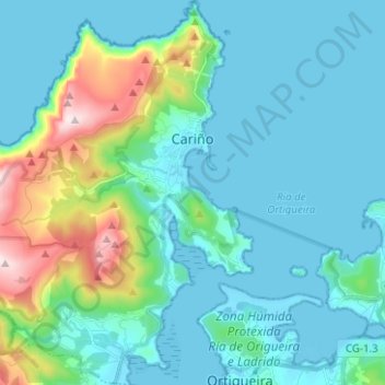
Name: Cariño topographic map, elevation, terrain.
Location: Cariño, Ortegal, A Coruña, Galicien, Spanien (43.68335 -7.95508 43.77374 -7.85010)
Average elevation: 96 m
Minimum elevation: -1 m
Maximum elevation: 547 m
Make a donation
Gear up for your next adventure:
As an Amazon Associate, this site earns from qualifying purchases at no extra cost to you.
Other topographic maps
Click on a map to view its topography, its elevation and its terrain.