Geolocate

Santa Rita topographic map

Click on the map to display elevation.

About this map

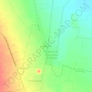
Name: Santa Rita topographic map, elevation, terrain.

Location: Santa Rita, Vetagrande, Zacatecas, Mexico (22.89189 -102.43586 22.93189 -102.39586)

Average elevation: 2,085 m

Minimum elevation: 2,060 m

Maximum elevation: 2,116 m

Gear up for your next adventure:

🔥Camping Stove - Portable stoves to cook outdoors with ease
🧴Waterproofing Spray - Restore the DWR coating on jackets and tents
🧦Outdoor Socks - Durable socks designed for hiking and outdoor sports
🧢Hiking Hat - Sun-protective and breathable hats for long treks
Camping Essentials - All-in-one gear for a comfortable camping trip

As an Amazon Associate, this site earns from qualifying purchases at no extra cost to you.