Geolocate

Bem topographic map

Click on the map to display elevation.

About this map

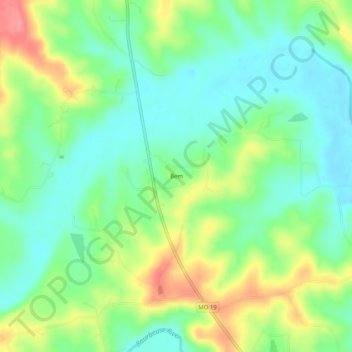
Name: Bem topographic map, elevation, terrain.

Location: Bem, Gasconade County, Missouri, United States (38.24588 -91.48988 38.28588 -91.44988)

Average elevation: 248 m

Minimum elevation: 218 m

Maximum elevation: 301 m

Other topographic maps

Click on a map to view its topography, its elevation and its terrain.

Bland

United States > Missouri > Gasconade County

Average elevation: 283 m

Owensville

United States > Missouri > Gasconade County

Average elevation: 279 m

Hermann

United States > Missouri > Gasconade County

Average elevation: 190 m

Gear up for your next adventure:

🛌Down Sleeping Bag - Superior warmth-to-weight ratio for cold nights
Bushcraft Tarp - Versatile emergency shelter or gear protection
💧Hydration Pack - Hands-free hydration system for long hikes
🚑Survival Whistle - Signal for help across long distances in mountains
🕶️Polarized Sunglasses - Protect your eyes with durable polarized lenses

As an Amazon Associate, this site earns from qualifying purchases at no extra cost to you.