Geolocate

Chullo topographic map

Click on the map to display elevation.

About this map

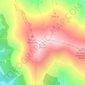
Name: Chullo topographic map, elevation, terrain.

Location: Chullo, Bayárcal, Almeria, Andalusia, Spain (37.09494 -3.00011 37.09504 -3.00001)

Average elevation: 2,302 m

Minimum elevation: 1,898 m

Maximum elevation: 2,606 m

Gear up for your next adventure:

🚲Handlebar Phone Mount - View topographic-map.com live while cycling
🧢Sun Hat - Wide-brim hat for sun protection
💡Solar Camping Lamp - Eco-friendly lighting for campsites
🛶Canoe Life Vest - Safety vest for water sports
🥾Waterproof Hiking Boots - Essential footwear for rugged terrain and wet Canadian trails

As an Amazon Associate, this site earns from qualifying purchases at no extra cost to you.