
Make a donation
Gear up for your next adventure:
As an Amazon Associate, this site earns from qualifying purchases at no extra cost to you.
Allentsteig topographic map
Click on the map to display elevation.
Make a donation
Gear up for your next adventure:
As an Amazon Associate, this site earns from qualifying purchases at no extra cost to you.
About this map
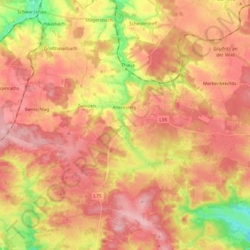
Name: Allentsteig topographic map, elevation, terrain.
Location: Allentsteig, Bezirk Zwettl, Lower Austria, 3804, Austria (48.63851 15.24532 48.73863 15.42875)
Average elevation: 568 m
Minimum elevation: 476 m
Maximum elevation: 627 m
Make a donation
Gear up for your next adventure:
As an Amazon Associate, this site earns from qualifying purchases at no extra cost to you.
Other topographic maps
Click on a map to view its topography, its elevation and its terrain.
Germanns
Austria > Lower Austria > Bezirk Zwettl > Gemeinde Zwettl-Niederösterreich
Average elevation: 604 m
Make a donation
Gear up for your next adventure:
As an Amazon Associate, this site earns from qualifying purchases at no extra cost to you.