Geolocate

Pajo topographic map

Click on the map to display elevation.

About this map

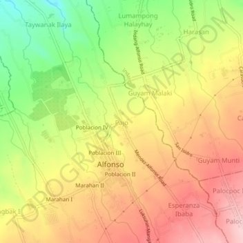
Name: Pajo topographic map, elevation, terrain.

Location: Pajo, Alfonso, Cavite, Calabarzon, 4123, Philippines (14.12506 120.83731 14.16506 120.87731)

Average elevation: 402 m

Minimum elevation: 286 m

Maximum elevation: 495 m

Other topographic maps

Click on a map to view its topography, its elevation and its terrain.

Amuyong

Philippines > Cavite > Alfonso

Average elevation: 543 m

Amuyong

Philippines > Cavite > Alfonso

Average elevation: 543 m

Gear up for your next adventure:

🥤Collapsible Travel Cup - Saves space and weight in your mess kit
🧴Waterproofing Spray - Restore the DWR coating on jackets and tents
🧤Insulated Winter Gloves - Heavy-duty protection for sub-zero Canadian adventures
🧶550 Survival Paracord - Versatile utility cord for emergency repairs and rigging
🥾Durable Hiking Shoes - Long-lasting shoes for frequent hiking

As an Amazon Associate, this site earns from qualifying purchases at no extra cost to you.