Geolocate

Le Pontreau topographic map

Click on the map to display elevation.

About this map
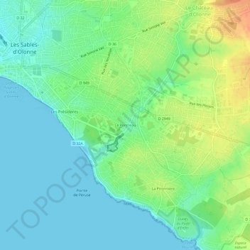
Name: Le Pontreau topographic map, elevation, terrain.

Location: Le Pontreau, Château-d'Olonne, Les Sables-d'Olonne, Vendée, Pays de la Loire, France métropolitaine, 85180, France (46.46670 -1.77344 46.50670 -1.73344)

Average elevation: 14 m

Minimum elevation: -1 m

Maximum elevation: 41 m

Other topographic maps

Click on a map to view its topography, its elevation and its terrain.

85180

France > Pays de la Loire > Vendée > Les Sables-d'Olonne

Average elevation: 28 m

Gear up for your next adventure:

🧥Packable Rain Jacket - Breathable waterproof layer for unpredictable weather
🧢Hiking Sun Hat - Wide-brimmed protection for exposed mountain ridges
🧊Insulated Water Bottle - Keeps drinks cold in summer and prevents freezing in winter
🛁Quick-Dry Microfiber Towel - Space-saving towel that dries rapidly on the move
🧼Biodegradable Camp Soap - Environmentally friendly cleaning for gear and body

As an Amazon Associate, this site earns from qualifying purchases at no extra cost to you.