Geolocate

Santa Rosa topographic map

Click on the map to display elevation.

About this map

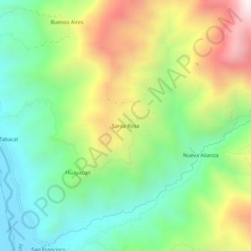
Name: Santa Rosa topographic map, elevation, terrain.

Location: Santa Rosa, Colasay, Jaén, Cajamarca, Perú (-5.75889 -79.03870 -5.71889 -78.99870)

Average elevation: 1,575 m

Minimum elevation: 1,127 m

Maximum elevation: 2,311 m

Other topographic maps

Click on a map to view its topography, its elevation and its terrain.

Río Huancabamba

Perú > Cajamarca > Colasay

Average elevation: 934 m

Gear up for your next adventure:

Family Camping Tent - Spacious tent suitable for family camping trips
🩹Moleskin Blister Pads - Direct protection for painful foot pressure points
🥾Hiking Boots - Sturdy boots providing ankle support and traction on rugged trails
🕶️Polarized Sunglasses - Protect your eyes with durable polarized lenses
🥾Hiking Shorts - Breathable shorts suitable for summer hikes

As an Amazon Associate, this site earns from qualifying purchases at no extra cost to you.