
Ocotal topographic map
Click on the map to display elevation.
Ocotal
Characterised by steep hills in the north and south, plateaus in the west and a valley in the center. It lies at an altitude of 500 metres (1,640 feet) above sea level.
About this map
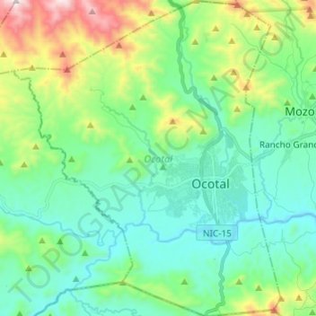
Name: Ocotal topographic map, elevation, terrain.
Location: Ocotal, Nueva Segovia, 37000, Nicaragua (13.58366 -86.55192 13.70140 -86.44947)
Average elevation: 756 m
Minimum elevation: 531 m
Maximum elevation: 1,435 m
Other topographic maps
Click on a map to view its topography, its elevation and its terrain.
Cerro Chachagua
Nicaragua > Nueva Segovia > Wiwilí de Nueva Segovia (Municipio)
Average elevation: 901 m