
Make a donation
Gear up for your next adventure:
As an Amazon Associate, this site earns from qualifying purchases at no extra cost to you.
Areguá topographic map
Click on the map to display elevation.
Make a donation
Gear up for your next adventure:
As an Amazon Associate, this site earns from qualifying purchases at no extra cost to you.
Areguá
Areguá is thought to come from Classical Guarani ariguâ·r ("[person/people] from above, from up there"), refererring to the area's high altitude and its first inhabitants from the Mbya Guarani tribes.
Make a donation
Gear up for your next adventure:
As an Amazon Associate, this site earns from qualifying purchases at no extra cost to you.
About this map
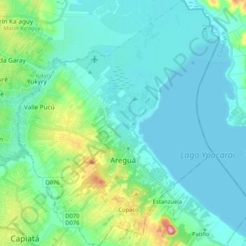
Name: Areguá topographic map, elevation, terrain.
Location: Areguá, Central Department, Región Oriental, Paraguay (-25.35888 -57.44770 -25.22742 -57.32782)
Average elevation: 89 m
Minimum elevation: 58 m
Maximum elevation: 241 m
Make a donation
Gear up for your next adventure:
As an Amazon Associate, this site earns from qualifying purchases at no extra cost to you.