
Make a donation
Gear up for your next adventure:
As an Amazon Associate, this site earns from qualifying purchases at no extra cost to you.
Monte Bano topographic map
Click on the map to display elevation.
Make a donation
Gear up for your next adventure:
As an Amazon Associate, this site earns from qualifying purchases at no extra cost to you.
Monte Bano
Il monte Bano (monte Bädo in ligure), 1035 m è posto tra la valle Scrivia e la val di Noci, nel comune di Montoggio. La sua prominenza topografica è di 143 m.
Make a donation
Gear up for your next adventure:
As an Amazon Associate, this site earns from qualifying purchases at no extra cost to you.
About this map
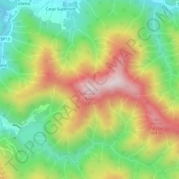
Name: Monte Bano topographic map, elevation, terrain.
Location: Monte Bano, Montoggio, Genova, Liguria, 16026, Italia (44.49949 9.04999 44.49959 9.05009)
Average elevation: 674 m
Minimum elevation: 430 m
Maximum elevation: 996 m
Make a donation
Gear up for your next adventure:
As an Amazon Associate, this site earns from qualifying purchases at no extra cost to you.