Geolocate

Sukorejo topographic map

Click on the map to display elevation.

About this map

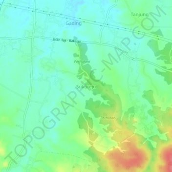
Name: Sukorejo topographic map, elevation, terrain.

Location: Sukorejo, Tambakrejo, Bojonegoro, East Java, Java, Indonesia (-7.29760 111.59089 -7.25760 111.63089)

Average elevation: 67 m

Minimum elevation: 45 m

Maximum elevation: 116 m

Other topographic maps

Click on a map to view its topography, its elevation and its terrain.

Gondang

Indonesia > East Java > Bojonegoro

Average elevation: 228 m

Sekar

Indonesia > East Java > Bojonegoro

Average elevation: 199 m

Gear up for your next adventure:

🧢Hiking Hat - Sun-protective and breathable hats for long treks
🧥Waterproof Pants - Keep dry during rainy hiking conditions
🚲Heavy Duty Bike Lock - Secure your bike at the trailhead or during stops
❄️Traction Ice Cleats - Slip-on spikes for icy trails and winter hiking
🥽Outdoor Goggles - Protective eyewear for outdoor activities

As an Amazon Associate, this site earns from qualifying purchases at no extra cost to you.