Geolocate

Bagerque topographic map

Click on the map to display elevation.

Bagerque

Bagergue es el municipio más alto del Valle de Arán, a 1419 m de altitud, situado a la izquierda del río Unhòla, afluente por el margen derecho del río Garona. El núcleo histórico forma parte del Inventario del Patrimonio Arquitectónico de Cataluña. Una carretera que termina en el pueblo desciende hasta Salardú.

Wikipedia (CC-BY-SA 3.0)

About this map

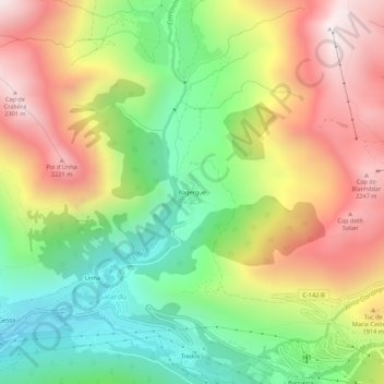
Name: Bagerque topographic map, elevation, terrain.

Location: Bagerque, Salardú, Alto Arán, Valle de Arán, Lérida, Cataluña, 25598, España (42.69910 0.89619 42.73910 0.93619)

Average elevation: 1,714 m

Minimum elevation: 1,200 m

Maximum elevation: 2,327 m

Gear up for your next adventure:

Camping Groundsheet - Protect your tent from moisture and dirt
Lightweight Backpacking Tent - Compact tent for efficient hiking trips
🥾Approach Shoes - Shoes designed for climbing approaches and rugged trails
🧢Outdoor Cap - Protective cap for sun and rain during hikes
🛏️Sleeping Bag - Warm and compact sleeping bags for outdoor camping

As an Amazon Associate, this site earns from qualifying purchases at no extra cost to you.