
Make a donation
Gear up for your next adventure:
As an Amazon Associate, this site earns from qualifying purchases at no extra cost to you.
Salzburg topographic map
Click on the map to display elevation.
Make a donation
Gear up for your next adventure:
As an Amazon Associate, this site earns from qualifying purchases at no extra cost to you.
About this map
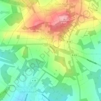
Name: Salzburg topographic map, elevation, terrain.
Average elevation: 576 m
Minimum elevation: 518 m
Maximum elevation: 660 m
Make a donation
Gear up for your next adventure:
As an Amazon Associate, this site earns from qualifying purchases at no extra cost to you.
Other topographic maps
Click on a map to view its topography, its elevation and its terrain.
Make a donation
Gear up for your next adventure:
As an Amazon Associate, this site earns from qualifying purchases at no extra cost to you.
Wasserschloß Bilkheim
Deutschland > Rheinland-Pfalz > Westerwaldkreis > Bilkheim
Average elevation: 312 m
Make a donation
Gear up for your next adventure:
As an Amazon Associate, this site earns from qualifying purchases at no extra cost to you.
Make a donation
Gear up for your next adventure:
As an Amazon Associate, this site earns from qualifying purchases at no extra cost to you.
Zinhain
Deutschland > Rheinland-Pfalz > Westerwaldkreis > Bad Marienberg (Westerwald)
Die Ortschaft liegt etwa zwei Kilometer westlich des Stadtzentrums von Bad Marienberg in Hanglage über dem Tal der südlich fließenden Nister auf einer Höhe von durchschnittlich circa 480 m ü. NHN und steigt nach Norden hin bis auf etwa 550 m ü. NHN auf der „Zinhainer Höhe“ an.
Average elevation: 438 m
Make a donation
Gear up for your next adventure:
As an Amazon Associate, this site earns from qualifying purchases at no extra cost to you.
Marienbad
Deutschland > Rheinland-Pfalz > Westerwaldkreis > Bad Marienberg (Westerwald) > Zinhain
Average elevation: 450 m
Make a donation
Gear up for your next adventure:
As an Amazon Associate, this site earns from qualifying purchases at no extra cost to you.
Fuchskaute
Deutschland > Rheinland-Pfalz > Westerwaldkreis > Willingen
Die Fuchskaute hat zwei etwa 650 m voneinander entfernte Kuppen – mit Höhen in Meter (m) über Normalhöhennull (NHN): die auch Alteberg genannte Nordkuppe (656,4 m) und die Südkuppe (657,3 m), wobei sich letztere in zwei rund 175 m auseinander liegende Anhöhen aufteilt, nämlich in die Nordanhöhe (657,3…
Average elevation: 609 m
Salzburger Kopf
Deutschland > Rheinland-Pfalz > Westerwaldkreis > Stein-Neukirch
Average elevation: 589 m
Make a donation
Gear up for your next adventure:
As an Amazon Associate, this site earns from qualifying purchases at no extra cost to you.
Steinefrenz Bahnhof
Deutschland > Rheinland-Pfalz > Westerwaldkreis > Steinefrenz
Average elevation: 270 m
Eichenstruth
Deutschland > Rheinland-Pfalz > Westerwaldkreis > Bad Marienberg (Westerwald)
Average elevation: 483 m