Geolocate

Jefferson topographic map

Click on the map to display elevation.

About this map

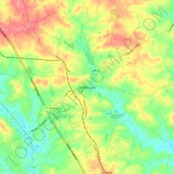
Name: Jefferson topographic map, elevation, terrain.

Location: Jefferson, Jackson County, Georgia, 30549, United States (34.07705 -83.61239 34.15705 -83.53239)

Average elevation: 245 m

Minimum elevation: 203 m

Maximum elevation: 294 m

Gear up for your next adventure:

🥾Lightweight Hiking Boots - Boots for comfort and mobility on long hikes
Family Camping Tent - Spacious tent suitable for family camping trips
🧊Insulated Water Bottle - Keeps drinks cold in summer and prevents freezing in winter
🥾Hiking Shorts - Breathable shorts suitable for summer hikes
🥾Trail Running Boots - Durable shoes designed for trail running

As an Amazon Associate, this site earns from qualifying purchases at no extra cost to you.