
Make a donation
Gear up for your next adventure:
As an Amazon Associate, this site earns from qualifying purchases at no extra cost to you.
Uhingen topographic map
Click on the map to display elevation.
Make a donation
Gear up for your next adventure:
As an Amazon Associate, this site earns from qualifying purchases at no extra cost to you.
Uhingen
Der Hauptort erstreckt sich über zwei Berghänge (Haldenberg / Wurmberg und Wasserberg) sowie das dazwischen liegende Filstal und liegt auf 256 bis 483 Metern Höhe. Im Nordwesten reicht das Stadtgebiet noch bis in den Schurwald hinein. Die Stadt liegt im Landkreis Göppingen und gehört damit zur Region Stuttgart und zum Regierungsbezirk Stuttgart.
Make a donation
Gear up for your next adventure:
As an Amazon Associate, this site earns from qualifying purchases at no extra cost to you.
About this map
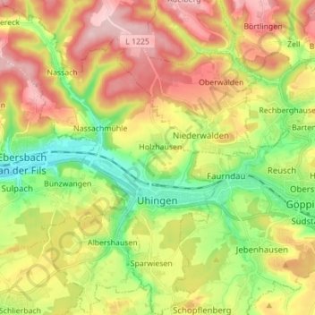
Name: Uhingen topographic map, elevation, terrain.
Average elevation: 374 m
Minimum elevation: 274 m
Maximum elevation: 489 m
Make a donation
Gear up for your next adventure:
As an Amazon Associate, this site earns from qualifying purchases at no extra cost to you.
Other topographic maps
Click on a map to view its topography, its elevation and its terrain.
Kölleshof
Deutschland > Baden-Württemberg > Landkreis Göppingen > Drackenstein
Average elevation: 740 m
Donzdorf
Deutschland > Baden-Württemberg > Landkreis Göppingen > Donzdorf
Donzdorf liegt im Tal der Donzdorfer Lauter, einem Seitental des Filstals, auf 334 bis 749 Meter Höhe (höchste Erhebung: Messelstein), etwa 12 km von der Kreisstadt Göppingen entfernt. Das Stadtgebiet erstreckt sich vom Rehgebirge im östlichen Albvorland bis auf die Hochfläche der Schwäbischen Alb im Süden.
Average elevation: 519 m