
Mount Middleton topographic map
Click on the map to display elevation.
About this map
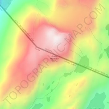
Name: Mount Middleton topographic map, elevation, terrain.
Location: Mount Middleton, Ketchikan Gateway, Alaska, United States (56.26499 -130.61550 56.26509 -130.61540)
Average elevation: 1,289 m
Minimum elevation: 846 m
Maximum elevation: 1,653 m
Other topographic maps
Click on a map to view its topography, its elevation and its terrain.
Ketchikan
United States > Alaska > Ketchikan Gateway > Ketchikan
Due to its steep and forested terrain, Ketchikan is long and narrow with much of the built-up area being located along, or no more than a few city blocks from, the waterfront. Elevations of inhabited areas range from just above sea level to about 300 feet (91 m). Deer Mountain, a 3,001-foot (915 m) peak, rises…
Average elevation: 149 m