Geolocate

Pointe Mistassini topographic map

Click on the map to display elevation.

About this map
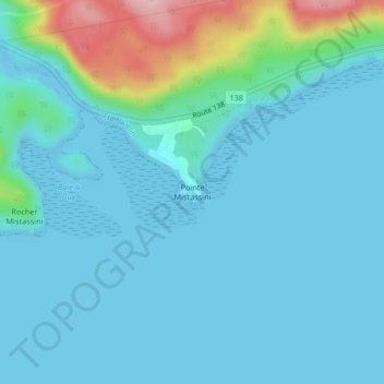
Name: Pointe Mistassini topographic map, elevation, terrain.

Location: Pointe Mistassini, Franquelin, Manicouagan, Côte-Nord, Québec, G0H 1E0, Canada (49.28191 -67.93826 49.28201 -67.93816)

Average elevation: 30 m

Minimum elevation: -3 m

Maximum elevation: 201 m

Other topographic maps

Click on a map to view its topography, its elevation and its terrain.

Lac Lessard

Canada > Québec > Manicouagan > Franquelin

Average elevation: 170 m

Lac Barron

Canada > Québec > Manicouagan > Franquelin

Average elevation: 118 m

Lac Lessard

Canada > Québec > Manicouagan > Franquelin

Average elevation: 170 m

Lac Brumeux

Canada > Québec > Manicouagan > Franquelin

Average elevation: 202 m

Gear up for your next adventure:

🥾Waterproof Hiking Boots - Boots keeping your feet dry in wet conditions
🛌Insulated Sleeping Pad - Critical thermal barrier between you and the cold ground
🥾Lightweight Hiking Shoes - Comfortable shoes for day hikes
🧢Sun Protection Cap - Breathable cap to protect from sun exposure
🧭GPS Handheld Device - Reliable GPS navigation for outdoor adventures

As an Amazon Associate, this site earns from qualifying purchases at no extra cost to you.