Geolocate

Binga topographic map

Click on the map to display elevation.

About this map

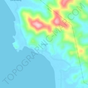
Name: Binga topographic map, elevation, terrain.

Location: Binga, Roxas, Palawan, Mimaropa, Philippines (10.72791 119.31764 10.76791 119.35764)

Average elevation: 43 m

Minimum elevation: -1 m

Maximum elevation: 249 m

Other topographic maps

Click on a map to view its topography, its elevation and its terrain.

Long Beach

Philippines > Palawan > Roxas > San Isidro

Average elevation: 4 m

Purao Island

Philippines > Palawan > Roxas

Average elevation: 0 m

Stanlake Island

Philippines > Palawan > Roxas

Average elevation: 0 m

Coconut Beach

Philippines > Palawan > Roxas

Average elevation: 23 m

Boayan

Philippines > Palawan > Roxas

Average elevation: 12 m

Gear up for your next adventure:

🥾Hiking Boots - Sturdy boots providing ankle support and traction on rugged trails
👟Sport Hiking Sandals - Breathable footwear for water crossings and camp rest
🏕️Camping Hammock - Integrated protection for sleeping between trees
🥫Freeze-Dried Meals - Lightweight, high-calorie nutrition for multi-day treks
🛶Waterproof Dry Bags - Keep electronics and clothes dry during river crossings

As an Amazon Associate, this site earns from qualifying purchases at no extra cost to you.