Geolocate

Mariawa topographic map

Click on the map to display elevation.

About this map

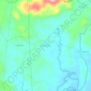
Name: Mariawa topographic map, elevation, terrain.

Location: Mariawa, Legazpi, Albay, Bicol Region, 4501, Philippines (13.07550 123.70385 13.11550 123.74385)

Average elevation: 56 m

Minimum elevation: 4 m

Maximum elevation: 260 m

Other topographic maps

Click on a map to view its topography, its elevation and its terrain.

Mayon Volcano

Philippines > Albay > Legazpi

Average elevation: 519 m

Sawangan Park

Philippines > Albay > Legazpi

Average elevation: 7 m

Kalayaan Park

Philippines > Albay > Legazpi

Average elevation: 7 m

Gear up for your next adventure:

🧦Outdoor Socks - Durable socks designed for hiking and outdoor sports
👟Sport Hiking Sandals - Breathable footwear for water crossings and camp rest
🛌Insulated Sleeping Pad - Critical thermal barrier between you and the cold ground
Bushcraft Tarp - Versatile emergency shelter or gear protection
🗺️Topographic Maps - Detailed maps to explore trails, mountains, and wilderness areas

As an Amazon Associate, this site earns from qualifying purchases at no extra cost to you.