Geolocate

Jacó topographic map

Click on the map to display elevation.

About this map

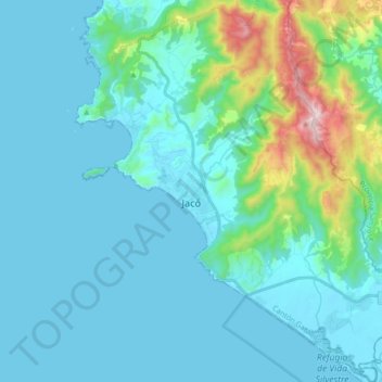
Name: Jacó topographic map, elevation, terrain.

Location: Jacó, Garabito, Puntarenas Province, 61101, Costa Rica (9.53603 -84.68053 9.70480 -84.52853)

Average elevation: 112 m

Minimum elevation: -1 m

Maximum elevation: 802 m

Other topographic maps

Click on a map to view its topography, its elevation and its terrain.

Punta Leona

Costa Rica > Garabito > Tárcoles

Average elevation: 21 m

Agujitas

Costa Rica > Garabito > Jacó

Average elevation: 472 m

Bajo Capulín

Costa Rica > Garabito > Lagunillas

Average elevation: 80 m

Gear up for your next adventure:

🦶Anti-Blister Balm - Prevents friction and hotspots during long ascents
💡Compact LED Flashlight - Powerful and portable flashlight for outdoor use
🧢Outdoor Visor - Breathable visor for sunny hikes
🧴First Aid Kit - Essential first aid supplies for outdoor emergencies
🧊Portable Cooler - Keep food and drinks cold during outdoor adventures

As an Amazon Associate, this site earns from qualifying purchases at no extra cost to you.