Geolocate

Basao topographic map

Click on the map to display elevation.

About this map

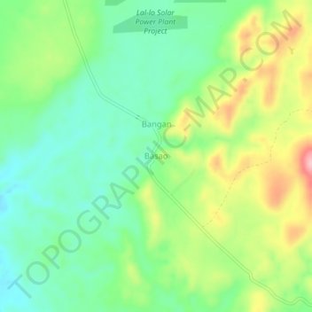
Name: Basao topographic map, elevation, terrain.

Location: Basao, Gattaran, Cagayan, Cagayan Valley, Philippines (18.07876 121.69337 18.11876 121.73337)

Average elevation: 90 m

Minimum elevation: 30 m

Maximum elevation: 194 m

Gear up for your next adventure:

🧢Beanie Hat - Keep your head warm in cold weather
🧢Hiking Sun Hat - Wide-brimmed protection for exposed mountain ridges
🏃Hydration Running Vest - Carry water and maps close to your body for speed
🧼Biodegradable Camp Soap - Environmentally friendly cleaning for gear and body
Lightweight Backpacking Tent - Compact tent for efficient hiking trips

As an Amazon Associate, this site earns from qualifying purchases at no extra cost to you.