Geolocate

Fleesensee topographic map

Click on the map to display elevation.

Fleesensee

Fleesensee is a lake in the Mecklenburgische Seenplatte district in Mecklenburg-Vorpommern, Germany. At an elevation of 62 metres (203 ft), its surface area is 10.78 square kilometres (4.16 sq mi).

Wikipedia (CC-BY-SA 3.0)

About this map

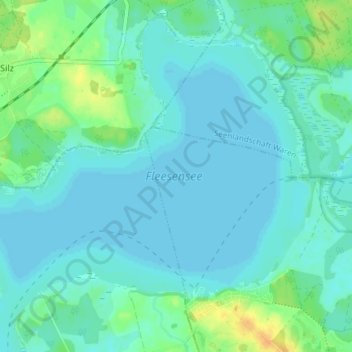
Name: Fleesensee topographic map, elevation, terrain.

Location: Fleesensee, Göhren-Lebbin, Malchow, Mecklenburgische Seenplatte, Mecklenburg-Vorpommern, Germany (53.48708 12.43069 53.52633 12.50458)

Average elevation: 65 m

Minimum elevation: 59 m

Maximum elevation: 87 m

Gear up for your next adventure:

💧Filtered Water Bottle - Safe drinking water on the go
🥾Lightweight Hiking Boots - Boots for comfort and mobility on long hikes
👟Leg Gaiters - Keep debris, mud, and snow out of your boots
🧭GPS Handheld Device - Reliable GPS navigation for outdoor adventures
🥾Waterproof Trail Shoes - Shoes designed to handle wet terrain

As an Amazon Associate, this site earns from qualifying purchases at no extra cost to you.