Geolocate

Utod topographic map

Click on the map to display elevation.

About this map

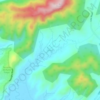
Name: Utod topographic map, elevation, terrain.

Location: Utod, Nasugbu, Batangas, Calabarzon, 4231, Philippines (14.09921 120.62725 14.13921 120.66725)

Average elevation: 117 m

Minimum elevation: 4 m

Maximum elevation: 418 m

Other topographic maps

Click on a map to view its topography, its elevation and its terrain.

Talamitam

Philippines > Batangas > Nasugbu > Kayrilaw

Average elevation: 328 m

Gear up for your next adventure:

🕶️Polarized Sunglasses - Protect your eyes with durable polarized lenses
🥾Waterproof Trail Shoes - Shoes designed to handle wet terrain
🔦LED Headtorch - Bright and durable light for night activities
🎒Hiking Backpack - Lightweight and ergonomic backpacks for day hikes or multi-day treks
🧥Fleece Jacket - Warm and lightweight jacket for layering

As an Amazon Associate, this site earns from qualifying purchases at no extra cost to you.