
Thank you for supporting this site ❤️
Make a donation
Make a donation
Gear up for your next adventure:
As an Amazon Associate, this site earns from qualifying purchases at no extra cost to you.
Nueros topographic map
Click on the map to display elevation.
Thank you for supporting this site ❤️
Make a donation
Make a donation
Gear up for your next adventure:
As an Amazon Associate, this site earns from qualifying purchases at no extra cost to you.
About this map
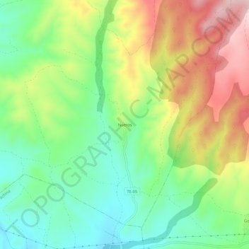
Name: Nueros topographic map, elevation, terrain.
Location: Nueros, Calamocha, Jiloca, Teruel, Aragón, España (40.90667 -1.14804 40.94667 -1.10804)
Average elevation: 1,151 m
Minimum elevation: 1,041 m
Maximum elevation: 1,309 m
Thank you for supporting this site ❤️
Make a donation
Make a donation
Gear up for your next adventure:
As an Amazon Associate, this site earns from qualifying purchases at no extra cost to you.