Geolocate

Inas topographic map

Click on the map to display elevation.

About this map

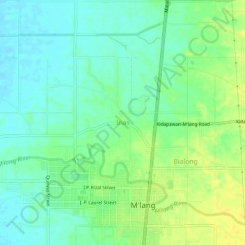
Name: Inas topographic map, elevation, terrain.

Location: Inas, M'lang, North Cotabato, Soccsksargen, 9402, Philippines (6.93803 124.86318 6.97803 124.90318)

Average elevation: 22 m

Minimum elevation: 13 m

Maximum elevation: 34 m

Gear up for your next adventure:

🧭GPS Tracker - Track your location in remote areas safely
🧦Hiking Liner Socks - Thin base layer to prevent friction and blisters
🦟Insect Repellent - Keep mosquitoes and black flies away in wooded areas
🧢Outdoor Cap - Protective cap for sun and rain during hikes
🔨Vehicle Emergency Tool - Safety tool for remote road trips to trailheads

As an Amazon Associate, this site earns from qualifying purchases at no extra cost to you.