
Make a donation
Gear up for your next adventure:
As an Amazon Associate, this site earns from qualifying purchases at no extra cost to you.
Braubach topographic map
Click on the map to display elevation.
Make a donation
Gear up for your next adventure:
As an Amazon Associate, this site earns from qualifying purchases at no extra cost to you.
Braubach
Die Stadt Braubach liegt im Rhein-Lahn-Kreis in Rheinland-Pfalz. Die Stadt gehört der Verbandsgemeinde Loreley an, deren größte Kommune sie mit über 3000 Einwohnern ist. Sie liegt im UNESCO-Welterbe Oberes Mittelrheintal. Besonders bekannt geworden ist sie durch die Lage unterhalb der Marksburg, der einzigen unzerstörten Höhenburg am Mittelrhein. Braubach ist gemäß Landesplanung als Grundzentrum ausgewiesen.
Make a donation
Gear up for your next adventure:
As an Amazon Associate, this site earns from qualifying purchases at no extra cost to you.
About this map
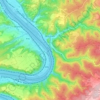
Name: Braubach topographic map, elevation, terrain.
Average elevation: 212 m
Minimum elevation: 65 m
Maximum elevation: 454 m
Make a donation
Gear up for your next adventure:
As an Amazon Associate, this site earns from qualifying purchases at no extra cost to you.
Other topographic maps
Click on a map to view its topography, its elevation and its terrain.
Burg Katz
Deutschland > Rheinland-Pfalz > Rhein-Lahn-Kreis > Sankt Goarshausen > Heide
Average elevation: 178 m