
Thank you for supporting this site ❤️
Make a donation
Make a donation
Gear up for your next adventure:
As an Amazon Associate, this site earns from qualifying purchases at no extra cost to you.
Cerdeira topographic map
Click on the map to display elevation.
Thank you for supporting this site ❤️
Make a donation
Make a donation
Gear up for your next adventure:
As an Amazon Associate, this site earns from qualifying purchases at no extra cost to you.
About this map
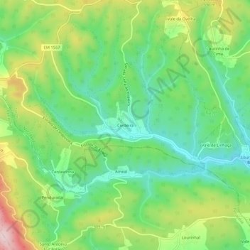
Name: Cerdeira topographic map, elevation, terrain.
Location: Cerdeira, Trezói, Mortágua, Viseu, 3360-016, Portugal (40.34528 -8.33686 40.38528 -8.29686)
Average elevation: 249 m
Minimum elevation: 138 m
Maximum elevation: 443 m
Thank you for supporting this site ❤️
Make a donation
Make a donation
Gear up for your next adventure:
As an Amazon Associate, this site earns from qualifying purchases at no extra cost to you.