
Make a donation
Gear up for your next adventure:
As an Amazon Associate, this site earns from qualifying purchases at no extra cost to you.
Jihlava topographic map
Click on the map to display elevation.
Make a donation
Gear up for your next adventure:
As an Amazon Associate, this site earns from qualifying purchases at no extra cost to you.
Jihlava
Jihlava is located in the heart of the Bohemian-Moravian Highlands. The northern part of the territory lies in the Upper Sázava Hills and the southern part lies in the Křižanov Highlands. The highest point is the hill Popický vrch with an elevation of 682 metres (2,238 ft), located on the southern municipal border.
Make a donation
Gear up for your next adventure:
As an Amazon Associate, this site earns from qualifying purchases at no extra cost to you.
About this map
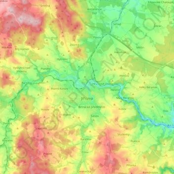
Name: Jihlava topographic map, elevation, terrain.
Location: Jihlava, okres Jihlava, Vysočina Region, Czechia (49.33394 15.49831 49.47592 15.66235)
Average elevation: 553 m
Minimum elevation: 441 m
Maximum elevation: 700 m
Make a donation
Gear up for your next adventure:
As an Amazon Associate, this site earns from qualifying purchases at no extra cost to you.