
Make a donation
Gear up for your next adventure:
As an Amazon Associate, this site earns from qualifying purchases at no extra cost to you.
Arnoldstein topographic map
Click on the map to display elevation.
Make a donation
Gear up for your next adventure:
As an Amazon Associate, this site earns from qualifying purchases at no extra cost to you.
About this map
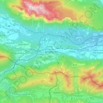
Name: Arnoldstein topographic map, elevation, terrain.
Location: Arnoldstein, Bezirk Villach-Land, Carinthia, Austria (46.50532 13.62190 46.59243 13.80863)
Average elevation: 927 m
Minimum elevation: 504 m
Maximum elevation: 2,157 m
Make a donation
Gear up for your next adventure:
As an Amazon Associate, this site earns from qualifying purchases at no extra cost to you.
Other topographic maps
Click on a map to view its topography, its elevation and its terrain.
Faak am See
Austria > Carinthia > Bezirk Villach-Land > Finkenstein am Faaker See > Faak am See
Average elevation: 601 m
Wurzach
Austria > Carinthia > Bezirk Villach-Land > Bad Bleiberg > Bleiberg-Kreuth
Average elevation: 1,186 m
Make a donation
Gear up for your next adventure:
As an Amazon Associate, this site earns from qualifying purchases at no extra cost to you.
Frießnitz/Breznica
Austria > Carinthia > Bezirk Villach-Land > St. Jakob im Rosental
Average elevation: 559 m
Oberwinklern
Austria > Carinthia > Bezirk Villach-Land > Velden am Wörther See
Average elevation: 753 m
Make a donation
Gear up for your next adventure:
As an Amazon Associate, this site earns from qualifying purchases at no extra cost to you.
Semering
Austria > Carinthia > Bezirk Villach-Land > Nötsch im Gailtal > Kühweg
Average elevation: 826 m
Make a donation
Gear up for your next adventure:
As an Amazon Associate, this site earns from qualifying purchases at no extra cost to you.