
Make a donation
Gear up for your next adventure:
As an Amazon Associate, this site earns from qualifying purchases at no extra cost to you.
Gizeux topographic map
Click on the map to display elevation.
Make a donation
Gear up for your next adventure:
As an Amazon Associate, this site earns from qualifying purchases at no extra cost to you.
Gizeux
L'Authion, d'une longueur totale de 99,8 km, prend sa source à 86 m d'altitude près de Bourgueil, à Hommes, à la fontaine de la Favrie. et se jette dans la Loire près d'Angers à Sainte-Gemmes-sur-Loire, à 15 m d'altitude, après avoir traversé 29 communes. Sur le plan piscicole, l'Authion est classé en deuxième catégorie piscicole. Le groupe biologique dominant est constitué essentiellement de poissons blancs (cyprinidés) et de carnassiers (brochet, sandre et perche).
Make a donation
Gear up for your next adventure:
As an Amazon Associate, this site earns from qualifying purchases at no extra cost to you.
About this map
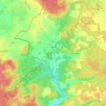
Name: Gizeux topographic map, elevation, terrain.
Average elevation: 78 m
Minimum elevation: 44 m
Maximum elevation: 113 m
Make a donation
Gear up for your next adventure:
As an Amazon Associate, this site earns from qualifying purchases at no extra cost to you.
Other topographic maps
Click on a map to view its topography, its elevation and its terrain.
Château de Cinq-Mars-la-Pile
France > Centre-Val de Loire > Indre-et-Loire > Cinq-Mars-la-Pile > Le Bourg
Average elevation: 61 m
Make a donation
Gear up for your next adventure:
As an Amazon Associate, this site earns from qualifying purchases at no extra cost to you.
La Proutière
France > Centre-Val de Loire > Indre-et-Loire > Épeigné-sur-Dême
Average elevation: 106 m
Make a donation
Gear up for your next adventure:
As an Amazon Associate, this site earns from qualifying purchases at no extra cost to you.
Chausseloup
France > Centre-Val de Loire > Indre-et-Loire > Chanceaux-sur-Choisille
Average elevation: 96 m
Make a donation
Gear up for your next adventure:
As an Amazon Associate, this site earns from qualifying purchases at no extra cost to you.
La Terre de la Ceuille Roulée
France > Centre-Val de Loire > Indre-et-Loire > Langeais
Average elevation: 89 m
Les Coutures
France > Centre-Val de Loire > Indre-et-Loire > La Ville-aux-Dames
Average elevation: 57 m
Make a donation
Gear up for your next adventure:
As an Amazon Associate, this site earns from qualifying purchases at no extra cost to you.
La Foire de Saint-Roch
France > Centre-Val de Loire > Indre-et-Loire > Saint-Roch
Average elevation: 96 m
Saint-Sulpice
France > Centre-Val de Loire > Indre-et-Loire > Chambourg-sur-Indre
Average elevation: 90 m
Make a donation
Gear up for your next adventure:
As an Amazon Associate, this site earns from qualifying purchases at no extra cost to you.
Make a donation
Gear up for your next adventure:
As an Amazon Associate, this site earns from qualifying purchases at no extra cost to you.
Le Buisson
France > Centre-Val de Loire > Indre-et-Loire > Tauxigny-Saint-Bauld
Average elevation: 97 m
Make a donation
Gear up for your next adventure:
As an Amazon Associate, this site earns from qualifying purchases at no extra cost to you.
La Grangette
France > Centre-Val de Loire > Indre-et-Loire > Montlouis-sur-Loire
Average elevation: 59 m
Île de Porteau
France > Centre-Val de Loire > Indre-et-Loire > La Chapelle-sur-Loire
Average elevation: 34 m
Make a donation
Gear up for your next adventure:
As an Amazon Associate, this site earns from qualifying purchases at no extra cost to you.
Les Chauvelles
France > Centre-Val de Loire > Indre-et-Loire > Azay-le-Rideau > Lionnière
Average elevation: 81 m
Parc du Lac des Bretonnières
France > Centre-Val de Loire > Indre-et-Loire > Joué-lès-Tours > La Petite Carte
Average elevation: 85 m
Make a donation
Gear up for your next adventure:
As an Amazon Associate, this site earns from qualifying purchases at no extra cost to you.
Make a donation
Gear up for your next adventure:
As an Amazon Associate, this site earns from qualifying purchases at no extra cost to you.
La Grange du Bois
France > Centre-Val de Loire > Indre-et-Loire > Épeigné-les-Bois
Average elevation: 105 m
La Tuilerie
France > Centre-Val de Loire > Indre-et-Loire > La Croix-en-Touraine
Average elevation: 74 m
Château de Villandry
France > Centre-Val de Loire > Indre-et-Loire > Villandry > Le Château
Average elevation: 64 m
Make a donation
Gear up for your next adventure:
As an Amazon Associate, this site earns from qualifying purchases at no extra cost to you.
Le Puy Mary
France > Centre-Val de Loire > Indre-et-Loire > Le Petit-Pressigny
Average elevation: 123 m
Make a donation
Gear up for your next adventure:
As an Amazon Associate, this site earns from qualifying purchases at no extra cost to you.
La Vallée des Caves
France > Centre-Val de Loire > Indre-et-Loire > Rochecorbon
Average elevation: 110 m
Le Carroi
France > Centre-Val de Loire > Indre-et-Loire > Mazières-de-Touraine
Average elevation: 91 m
Make a donation
Gear up for your next adventure:
As an Amazon Associate, this site earns from qualifying purchases at no extra cost to you.
Make a donation
Gear up for your next adventure:
As an Amazon Associate, this site earns from qualifying purchases at no extra cost to you.
Parc du Val de Loire
France > Centre-Val de Loire > Indre-et-Loire > Montlouis-sur-Loire > Le Bourg
Average elevation: 63 m
Les Ansaults
France > Centre-Val de Loire > Indre-et-Loire > Artannes-sur-Indre
Average elevation: 73 m
Le Sabot Rouge
France > Centre-Val de Loire > Indre-et-Loire > Sainte-Maure-de-Touraine
Average elevation: 98 m
Make a donation
Gear up for your next adventure:
As an Amazon Associate, this site earns from qualifying purchases at no extra cost to you.
La Blottière
France > Centre-Val de Loire > Indre-et-Loire > Beaumont-Louestault
Average elevation: 121 m
Les Availlons
France > Centre-Val de Loire > Indre-et-Loire > Yzeures-sur-Creuse
Average elevation: 93 m
Le Bois de la Grille
France > Centre-Val de Loire > Indre-et-Loire > Chinon > Le Villier
Average elevation: 75 m
Make a donation
Gear up for your next adventure:
As an Amazon Associate, this site earns from qualifying purchases at no extra cost to you.
Les Hucherolles
France > Centre-Val de Loire > Indre-et-Loire > Chinon > Les Hucherolles
Average elevation: 57 m
Le Boulay
France > Centre-Val de Loire > Indre-et-Loire > Villedômer > Le Boulay
Average elevation: 118 m
Les Poulardières
France > Centre-Val de Loire > Indre-et-Loire > Saint-Cyr-sur-Loire
Average elevation: 70 m
Make a donation
Gear up for your next adventure:
As an Amazon Associate, this site earns from qualifying purchases at no extra cost to you.
Le Télégraphe
France > Centre-Val de Loire > Indre-et-Loire > Chambray-lès-Tours
Average elevation: 86 m
Le Grand Village
France > Centre-Val de Loire > Indre-et-Loire > La Ville-aux-Dames
Average elevation: 51 m
Make a donation
Gear up for your next adventure:
As an Amazon Associate, this site earns from qualifying purchases at no extra cost to you.
Les Muriers
France > Centre-Val de Loire > Indre-et-Loire > Saint-Pierre-des-Corps
Average elevation: 58 m
Make a donation
Gear up for your next adventure:
As an Amazon Associate, this site earns from qualifying purchases at no extra cost to you.
La Grosse Chaintre
France > Centre-Val de Loire > Indre-et-Loire > La Ville-aux-Dames
Average elevation: 61 m
Make a donation
Gear up for your next adventure:
As an Amazon Associate, this site earns from qualifying purchases at no extra cost to you.
La Derouette
France > Centre-Val de Loire > Indre-et-Loire > Coteaux-sur-Loire
Average elevation: 47 m
La Blonderie
France > Centre-Val de Loire > Indre-et-Loire > Beaumont-Louestault
Average elevation: 131 m
Make a donation
Gear up for your next adventure:
As an Amazon Associate, this site earns from qualifying purchases at no extra cost to you.
Make a donation
Gear up for your next adventure:
As an Amazon Associate, this site earns from qualifying purchases at no extra cost to you.
Pièce de Ferrière
France > Centre-Val de Loire > Indre-et-Loire > Athée-sur-Cher
Average elevation: 79 m
Make a donation
Gear up for your next adventure:
As an Amazon Associate, this site earns from qualifying purchases at no extra cost to you.
Le Mee
France > Centre-Val de Loire > Indre-et-Loire > Neuillé-le-Lierre > Le Feuillet
Average elevation: 103 m
Make a donation
Gear up for your next adventure:
As an Amazon Associate, this site earns from qualifying purchases at no extra cost to you.
Make a donation
Gear up for your next adventure:
As an Amazon Associate, this site earns from qualifying purchases at no extra cost to you.