
Make a donation
Gear up for your next adventure:
As an Amazon Associate, this site earns from qualifying purchases at no extra cost to you.
Les Combes topographic map
Click on the map to display elevation.
Make a donation
Gear up for your next adventure:
As an Amazon Associate, this site earns from qualifying purchases at no extra cost to you.
About this map
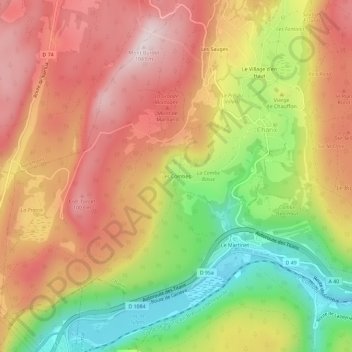
Name: Les Combes topographic map, elevation, terrain.
Average elevation: 837 m
Minimum elevation: 574 m
Maximum elevation: 1,050 m
Make a donation
Gear up for your next adventure:
As an Amazon Associate, this site earns from qualifying purchases at no extra cost to you.
Other topographic maps
Click on a map to view its topography, its elevation and its terrain.
Lac Genin
France > Auvergne-Rhône-Alpes > Ain > Charix
Le lac Genin est un lac de moyenne altitude du massif du Jura. Il se situe au milieu d'une forêt typiquement jurassienne, composée de sapins, d'épicéas et de feuillus. Le site est surnommé « le petit Canada du Haut-Bugey » et est classé site pittoresque depuis le 1er mars 1935.
Average elevation: 908 m