Geolocate

Rosses Point topographic map

Click on the map to display elevation.

About this map

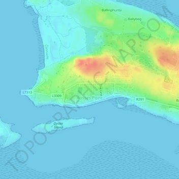
Name: Rosses Point topographic map, elevation, terrain.

Location: Rosses Point, County Sligo, Connacht, Ireland (54.30197 -8.56761 54.31236 -8.52688)

Average elevation: 8 m

Minimum elevation: -1 m

Maximum elevation: 46 m

Other topographic maps

Click on a map to view its topography, its elevation and its terrain.

Knocknarea

Ireland > County Sligo

Average elevation: 104 m

Markree Castle

Ireland > County Sligo

Average elevation: 36 m

Rosses Point

Ireland > County Sligo

Average elevation: 4 m

Gear up for your next adventure:

🔪Outdoor Multitool - Versatile tool for repairs and food prep in the wild
❄️Traction Ice Cleats - Slip-on spikes for icy trails and winter hiking
🩹Compact First Aid Kit - Pre-packed essentials for common trail injuries
🔦LED Flashlight - Powerful and long-lasting flashlight for camping and emergencies
🦶Anti-Blister Balm - Prevents friction and hotspots during long ascents

As an Amazon Associate, this site earns from qualifying purchases at no extra cost to you.