
Buchbach topographic map
Click on the map to display elevation.
About this map
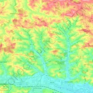
Name: Buchbach topographic map, elevation, terrain.
Average elevation: 462 m
Minimum elevation: 419 m
Maximum elevation: 517 m
Other topographic maps
Click on a map to view its topography, its elevation and its terrain.
Hofthambach
Deutschland > Bayern > Landkreis Mühldorf am Inn > Neumarkt-Sankt Veit > Wiesbach
Average elevation: 475 m
Leoprechting
Deutschland > Bayern > Landkreis Mühldorf am Inn > Niedertaufkirchen
Average elevation: 466 m
Mühldorf am Inn
Deutschland > Bayern > Landkreis Mühldorf am Inn > Mühldorf a. Inn > Mühldorf am Inn
Average elevation: 402 m
Furth
Deutschland > Bayern > Landkreis Mühldorf am Inn > Oberflossing > Furth
Average elevation: 418 m
Zaismaier
Deutschland > Bayern > Landkreis Mühldorf am Inn > Stefanskirchen > Zaismaier
Average elevation: 447 m
Manholding
Deutschland > Bayern > Landkreis Mühldorf am Inn > Oberbergkirchen
Average elevation: 480 m
Heisting
Deutschland > Bayern > Landkreis Mühldorf am Inn > Kraiburg > Frauendorf
Average elevation: 412 m
Oberwiesbach
Deutschland > Bayern > Landkreis Mühldorf am Inn > Neumarkt-Sankt Veit > Wiesbach
Average elevation: 480 m
Sankt Erasmus
Deutschland > Bayern > Landkreis Mühldorf am Inn > Waldkraiburg
Average elevation: 418 m
Forchöd
Deutschland > Bayern > Landkreis Mühldorf am Inn > Haag in Oberbayern
Average elevation: 508 m
Teising
Deutschland > Bayern > Landkreis Mühldorf am Inn > Neumarkt-Sankt Veit
Average elevation: 464 m
Schloss Teising
Deutschland > Bayern > Landkreis Mühldorf am Inn > Neumarkt-Sankt Veit > Teising
Average elevation: 461 m
Altdorf
Deutschland > Bayern > Landkreis Mühldorf am Inn > Haag in Oberbayern
Average elevation: 526 m
Schloss Guttenburg
Deutschland > Bayern > Landkreis Mühldorf am Inn > Kraiburg > Frauendorf
Average elevation: 427 m