Geolocate

Centennial topographic map

Click on the map to display elevation.

About this map

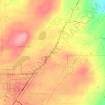
Name: Centennial topographic map, elevation, terrain.

Location: Centennial, Calumet Township, Houghton County, Michigan, 49942, United States (47.23826 -88.44873 47.27826 -88.40873)

Average elevation: 357 m

Minimum elevation: 273 m

Maximum elevation: 399 m

Other topographic maps

Click on a map to view its topography, its elevation and its terrain.

Copper City

United States > Michigan > Houghton County

Average elevation: 272 m

Lake Linden

United States > Michigan > Houghton County

Average elevation: 206 m

Laurium

United States > Michigan > Houghton County

Average elevation: 366 m

Gear up for your next adventure:

💡LED Headlamp - Hands-free illumination for night hiking and camping
🥾Waterproof Hiking Shoes - Durable shoes for wet and rugged trails
🕯️Camping Lantern - Illuminates your entire campsite with high-efficiency LEDs
🧳Compression Sacks - Maximize space in your backpack by shrinking gear
🔦UV Flashlight - Detect minerals or specific insects in the dark

As an Amazon Associate, this site earns from qualifying purchases at no extra cost to you.