
Make a donation
Gear up for your next adventure:
As an Amazon Associate, this site earns from qualifying purchases at no extra cost to you.
Catterlen topographic map
Click on the map to display elevation.
Make a donation
Gear up for your next adventure:
As an Amazon Associate, this site earns from qualifying purchases at no extra cost to you.
About this map
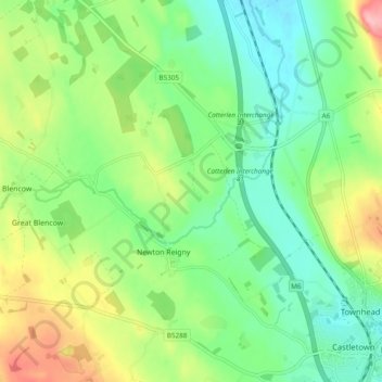
Name: Catterlen topographic map, elevation, terrain.
Location: Catterlen, Westmorland and Furness, England, United Kingdom (54.65926 -2.83734 54.71470 -2.78017)
Average elevation: 175 m
Minimum elevation: 126 m
Maximum elevation: 268 m
Make a donation
Gear up for your next adventure:
As an Amazon Associate, this site earns from qualifying purchases at no extra cost to you.
Other topographic maps
Click on a map to view its topography, its elevation and its terrain.
Pendragon Castle
United Kingdom > England > Westmorland and Furness > Outhgill
Average elevation: 345 m
Make a donation
Gear up for your next adventure:
As an Amazon Associate, this site earns from qualifying purchases at no extra cost to you.
Kearstwick
United Kingdom > England > Westmorland and Furness > South Lakeland > Kirkby Lonsdale
Average elevation: 95 m