
Passau topographic map
Click on the map to display elevation.
Passau
Das Klimadiagramm gibt die Daten einer Messstelle in Fürstenzell (südwestlich an Passau angrenzend) wieder. Allerdings liegt diese Messstelle nahezu 100 Meter höher als Passau selbst.
About this map
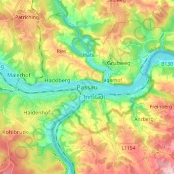
Name: Passau topographic map, elevation, terrain.
Location: Passau, Niederbayern, Bayern, 94032, Deutschland (48.53482 13.42097 48.61482 13.50097)
Average elevation: 380 m
Minimum elevation: 287 m
Maximum elevation: 507 m