Geolocate

Punta Ala topographic map

Click on the map to display elevation.

About this map

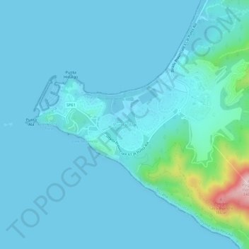
Name: Punta Ala topographic map, elevation, terrain.

Location: Punta Ala, Castiglione della Pescaia, Grosseto, Tuscany, Italy (42.78126 10.73113 42.82126 10.77113)

Average elevation: 31 m

Minimum elevation: -2 m

Maximum elevation: 331 m

Other topographic maps

Click on a map to view its topography, its elevation and its terrain.

Isola del Giglio

Italy > Tuscany > Grosseto > Giglio Castello

Average elevation: 57 m

Gear up for your next adventure:

🧴Sunscreen SPF - Broad-spectrum sunscreen for outdoor activities
🧊Portable Cooler - Keep food and drinks cold during outdoor adventures
🍽️Titanium Camping Spork - Ultralight and indestructible eating utensil
🧴Bear Spray Holster - Quick-access carry for essential Canadian wilderness safety
🥾Approach Boots - Comfortable boots for hiking and climbing approaches

As an Amazon Associate, this site earns from qualifying purchases at no extra cost to you.