
Make a donation
Gear up for your next adventure:
As an Amazon Associate, this site earns from qualifying purchases at no extra cost to you.
Abernathy topographic map
Click on the map to display elevation.
Make a donation
Gear up for your next adventure:
As an Amazon Associate, this site earns from qualifying purchases at no extra cost to you.
Abernathy
Abernathy (elevation 3,360 feet) is located at 33°49′56″N 101°50′35″W / 33.83222°N 101.84306°W / 33.83222; -101.84306 (33.8323038, –101.8429491). Most of the city is located in Hale County; roughly 25% of the city extends southward into Lubbock County.
Make a donation
Gear up for your next adventure:
As an Amazon Associate, this site earns from qualifying purchases at no extra cost to you.
About this map
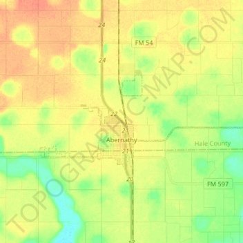
Name: Abernathy topographic map, elevation, terrain.
Location: Abernathy, Hale County, Texas, 79311, United States (33.81949 -101.88752 33.86162 -101.75546)
Average elevation: 1,020 m
Minimum elevation: 1,000 m
Maximum elevation: 1,035 m
Make a donation
Gear up for your next adventure:
As an Amazon Associate, this site earns from qualifying purchases at no extra cost to you.
Other topographic maps
Click on a map to view its topography, its elevation and its terrain.
Abernathy
United States > Texas > Hale County
Abernathy (elevation 3,360 feet) is located at 33°49′56″N 101°50′35″W / 33.83222°N 101.84306°W / 33.83222; -101.84306 (33.8323038, –101.8429491). Most of the city is located in Hale County; roughly 25% of the city extends southward into Lubbock County.
Average elevation: 1,020 m