
Thank you for supporting this site ❤️
Make a donation
Make a donation
Gear up for your next adventure:
As an Amazon Associate, this site earns from qualifying purchases at no extra cost to you.
Vilcacoto topographic map
Click on the map to display elevation.
Thank you for supporting this site ❤️
Make a donation
Make a donation
Gear up for your next adventure:
As an Amazon Associate, this site earns from qualifying purchases at no extra cost to you.
About this map
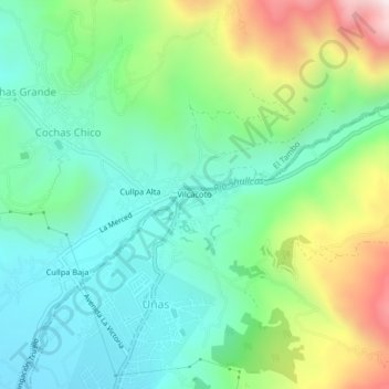
Name: Vilcacoto topographic map, elevation, terrain.
Location: Vilcacoto, Huancayo, Junín, 12002, Perú (-12.03315 -75.20148 -11.99315 -75.16148)
Average elevation: 3,596 m
Minimum elevation: 3,335 m
Maximum elevation: 4,198 m
Thank you for supporting this site ❤️
Make a donation
Make a donation
Gear up for your next adventure:
As an Amazon Associate, this site earns from qualifying purchases at no extra cost to you.