Geolocate

Moula Ali topographic map

Click on the map to display elevation.

About this map

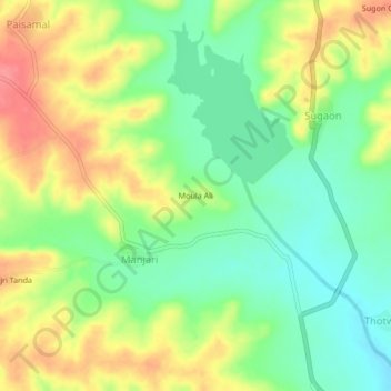
Name: Moula Ali topographic map, elevation, terrain.

Location: Moula Ali, Manjari, Mukhed, Nanded, Maharashtra, India (18.57296 77.29071 18.61296 77.33071)

Average elevation: 453 m

Minimum elevation: 420 m

Maximum elevation: 495 m

Gear up for your next adventure:

Lightweight Camping Tent - Portable shelter optimized for Canadian backcountry camping
🧥Packable Rain Jacket - Breathable waterproof layer for unpredictable weather
🧤Rechargeable Heated Gloves - Extreme warmth for Canadian winter expeditions
Camping Coffee Maker - Brew fresh coffee anywhere on the topographic map
🍽️Titanium Camping Spork - Ultralight and indestructible eating utensil

As an Amazon Associate, this site earns from qualifying purchases at no extra cost to you.