
Make a donation
Gear up for your next adventure:
As an Amazon Associate, this site earns from qualifying purchases at no extra cost to you.
Dallas Township topographic map
Click on the map to display elevation.
Make a donation
Gear up for your next adventure:
As an Amazon Associate, this site earns from qualifying purchases at no extra cost to you.
About this map
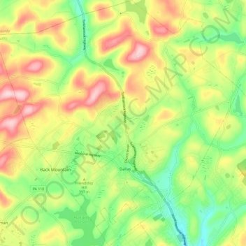
Name: Dallas Township topographic map, elevation, terrain.
Location: Dallas Township, Luzerne County, Pennsylvania, United States (41.30873 -76.02541 41.39608 -75.90934)
Average elevation: 387 m
Minimum elevation: 284 m
Maximum elevation: 516 m
Make a donation
Gear up for your next adventure:
As an Amazon Associate, this site earns from qualifying purchases at no extra cost to you.
Other topographic maps
Click on a map to view its topography, its elevation and its terrain.
Ricketts Glen State Park
United States > Pennsylvania > Luzerne County > Fairmount Township
The state's original plans for the new park included building an inn, an 18-hole golf course and country club, and a winter sports complex for skiing, ice boating, and tobogganing, as well as a beach with bathing facilities, cabins, and a tent camping area. Only the last three were actually built, all south of…
Average elevation: 588 m
Make a donation
Gear up for your next adventure:
As an Amazon Associate, this site earns from qualifying purchases at no extra cost to you.
Wapwallopen
United States > Pennsylvania > Luzerne County > Conyngham Township
Average elevation: 223 m
Make a donation
Gear up for your next adventure:
As an Amazon Associate, this site earns from qualifying purchases at no extra cost to you.
Town Hill
United States > Pennsylvania > Luzerne County > Huntington Township
Average elevation: 281 m
Roaring Brook
United States > Pennsylvania > Luzerne County > Hunlock Township
Average elevation: 337 m
Make a donation
Gear up for your next adventure:
As an Amazon Associate, this site earns from qualifying purchases at no extra cost to you.
Fern Glen
United States > Pennsylvania > Luzerne County > Black Creek Township
Average elevation: 391 m
Make a donation
Gear up for your next adventure:
As an Amazon Associate, this site earns from qualifying purchases at no extra cost to you.
Make a donation
Gear up for your next adventure:
As an Amazon Associate, this site earns from qualifying purchases at no extra cost to you.
Liewellyn Corners
United States > Pennsylvania > Luzerne County > Bear Creek Township
Average elevation: 449 m
Wapwallopen
United States > Pennsylvania > Luzerne County > Conyngham Township
Average elevation: 223 m
Make a donation
Gear up for your next adventure:
As an Amazon Associate, this site earns from qualifying purchases at no extra cost to you.
Glen Summit
United States > Pennsylvania > Luzerne County > Fairview Township
Average elevation: 539 m
Make a donation
Gear up for your next adventure:
As an Amazon Associate, this site earns from qualifying purchases at no extra cost to you.
Hunlock Creek
United States > Pennsylvania > Luzerne County > Hunlock Township > Hunlock
Average elevation: 276 m
Huntington Mills
United States > Pennsylvania > Luzerne County > Huntington Township
Average elevation: 289 m
Make a donation
Gear up for your next adventure:
As an Amazon Associate, this site earns from qualifying purchases at no extra cost to you.
Make a donation
Gear up for your next adventure:
As an Amazon Associate, this site earns from qualifying purchases at no extra cost to you.
Fern Glen
United States > Pennsylvania > Luzerne County > Black Creek Township
Average elevation: 391 m
South Pond Dam
United States > Pennsylvania > Luzerne County > Hanover Township
Average elevation: 204 m
Make a donation
Gear up for your next adventure:
As an Amazon Associate, this site earns from qualifying purchases at no extra cost to you.