Geolocate

Fairhaven topographic map

Click on the map to display elevation.

About this map

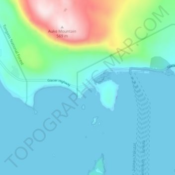
Name: Fairhaven topographic map, elevation, terrain.

Location: Fairhaven, Juneau, Alaska, United States (58.35806 -134.72361 58.39806 -134.68361)

Average elevation: 100 m

Minimum elevation: -27 m

Maximum elevation: 563 m

Other topographic maps

Click on a map to view its topography, its elevation and its terrain.

Mendenhall Glacier

United States > Alaska > Juneau

Average elevation: 359 m

Lemon Creek

United States > Alaska > Juneau

Average elevation: 431 m

Lena Beach

United States > Alaska > Juneau > Lena Beach

Average elevation: 103 m

West Juneau

United States > Alaska > Juneau

Average elevation: 110 m

Gear up for your next adventure:

🔥Camping Stove - Portable stoves to cook outdoors with ease
🧣Evaporative Cooling Towel - Beat the heat during intense summer climbs
🛶Kayak Dry Bag - Waterproof storage for kayaking adventures
🧦Merino Wool Socks - Moisture-wicking comfort for long-distance hiking
🥾Approach Shoes - Shoes designed for climbing approaches and rugged trails

As an Amazon Associate, this site earns from qualifying purchases at no extra cost to you.