Geolocate

Casili topographic map

Click on the map to display elevation.

About this map

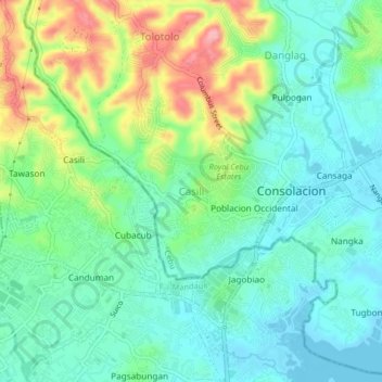
Name: Casili topographic map, elevation, terrain.

Location: Casili, Cebu, Central Visayas, 6001, Philippines (10.35595 123.92625 10.39595 123.96625)

Average elevation: 37 m

Minimum elevation: -1 m

Maximum elevation: 119 m

Other topographic maps

Click on a map to view its topography, its elevation and its terrain.

Boljoon River

Philippines > Cebu > Boljoon > Lower Becerril

Average elevation: 64 m

Cordova

Philippines > Cebu

The surface of the town consists entirely of karstic limestone rock geologically associated with the Plio-Pleistocene Carcar Formation, dated to 2½–3 million years ago. The topography of Cordova is flat land, the highest point being only 10 metres (33 ft) above sea level.

Average elevation: 0 m

Malapascua

Philippines > Cebu > Logon

Average elevation: 1 m

Logon

Philippines > Cebu

Average elevation: 1 m

Luyang River

Philippines > Cebu > Carmen

Average elevation: 58 m

Toledo City Plaza

Philippines > Cebu > Toledo

Average elevation: 9 m

Gear up for your next adventure:

🔋Solar Power Bank - Keep your GPS and devices charged during long outdoor trips
🚲MTB Frame Bag - Carry tools and maps directly on your bicycle frame
🏕️Camping Hammock - Integrated protection for sleeping between trees
🛏️Sleeping Bag - Warm and compact sleeping bags for outdoor camping
🧭Orienteering Kit - Tools for map reading and navigation in the wild

As an Amazon Associate, this site earns from qualifying purchases at no extra cost to you.