
Make a donation
Gear up for your next adventure:
As an Amazon Associate, this site earns from qualifying purchases at no extra cost to you.
Madrid Township topographic map
Click on the map to display elevation.
Make a donation
Gear up for your next adventure:
As an Amazon Associate, this site earns from qualifying purchases at no extra cost to you.
Madrid Township
Although Madrid's northern topography is mountainous, other parts suited cultivation. In 1837, when the population was 351, farms harvested 3,387 bushels of wheat.
Make a donation
Gear up for your next adventure:
As an Amazon Associate, this site earns from qualifying purchases at no extra cost to you.
About this map
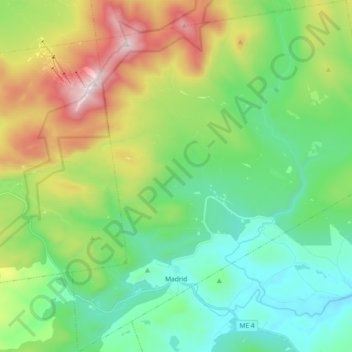
Name: Madrid Township topographic map, elevation, terrain.
Location: Madrid Township, Franklin County, Maine, United States (44.83732 -70.51628 44.96741 -70.34894)
Average elevation: 522 m
Minimum elevation: 199 m
Maximum elevation: 1,246 m
Make a donation
Gear up for your next adventure:
As an Amazon Associate, this site earns from qualifying purchases at no extra cost to you.
Other topographic maps
Click on a map to view its topography, its elevation and its terrain.
Make a donation
Gear up for your next adventure:
As an Amazon Associate, this site earns from qualifying purchases at no extra cost to you.